The foreign and university research ministries on Monday announced the first commercial gains for a ground-breaking Italian satellite system for Earth observation and disaster prevention.
COSMO-Skymed, which the government funds through the Italian Space Agency (ASI), has obtained a 180-million-euro contract with ''several'' Middle East, North African and south-east Asian countries, the ministries said.
The company set up to market the satellite system's products, e-GEOS, signed the contract with the 4C Satellite Images and Technologies company, they said.
There are prospects of further gains in China, Japan and the United States after ''positive'' contacts by e-GEOS, they added.
The third of COSMO-Skymed's four satellites was launched in late October and the fourth is scheduled to complete the system at the start of next year.
A second generation of Skymed is already planned.
With a final price tag of some one billion euros, the project is Italy's biggest ever in space and the world's first major satellite system destined for both civilian and military purposes, including environmental protection and homeland security.
The system will also generate ASI's first ever commercial returns.
Skymed's special radars are able to see through any weather condition at any time of the day or night, providing dual-purpose 3-D pictures for the scientific and military community.
According to the company that runs it, Telespazio, it is a technology ''that the whole world envies''.
ASI President Giovanni Bignami stressed that ''COSMO-Skymed is a wholly Italian programme and the only one of its kind in the world''.
MAPPING DISASTERS.
COSMO-Skymed 1 sent back spectacular, detailed pictures of natural disasters such as a huge rockslide in northern Italy, the disastrous wreck of a Russian tanker in the Black Sea and the catastrophic floods in Bangladesh, covering almost seven million square kilometres.
Skymed 2 more than doubled that capacity, taking the Italian satellite system's mapping coverage up to one and a half million square kilometres.
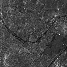
Similar gains are expected with COSMO 3 - which has already sent back detailed pictures of Turin, Paris and San Francisco - and COSMO 4.
COSMO will be available for civil, military and scientific communities to monitor the Earth's environment and security risks.
Its synthetic aperture radar (SAR) sensors will enable groups to quickly respond to natural disasters like volcanic eruptions, earthquakes, mudslides and floods.


