Dolceacqua, the Ligurian Village Painted By Monet
ITA:

Use player to listen to Italian version
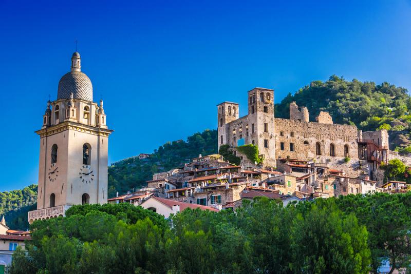
French Impressionist painter Claude Monet made it the subject of some of his famous paintings, and called it a “jewel of lightness.” Dolceacqua (literally, ‘sweet water’) is a typical medieval village of Val Nervia, on the hills of the Ligurian hinterland between Ventimiglia and Bordighera, in the western portion of the Italian Riviera, close to the border with France. The Castle of the Doria overlooks the old part of the village, at the foot of Mount Rebuffao, which the residents call Terra (‘earth’). The modern part, called Borgo, develops on the opposite bank of the river Nervia.
Two panels reproducing two paintings by Monet, who painted Dolceacqua’s bridge and the castle, have been positioned in the exact place where the artist placed his easel.
Dolceacqua was the impregnable fortress of the Republic of Genoa until the Napoleonic era. Strolling the typical carugi streets, visitors will find many artists' workshops, handicraft shops, cellars and grocery stores selling typical products.
The Ponte Vecchio of Dolceacqua (Old Bridge) painted by Monet is a masterpiece of harmony and elegance, formed by a single round arch 32 meters long, built in 1400.
The castle, where capital punishments were carried out, once marked the border between Liguria and Piedmont. During the Renaissance, it became a fortified noble residence, with new frescoed and furnished rooms.
Although the medieval village is rather small, there are many religious buildings to visit, including the Church of San Bernardino, famous for its medieval frescoes; the Church of Sant'Agostino, which houses some ancient statues; the Collegiate, rich in works of art; the oratory of San Giovanni Battista, with its many paintings; and the Church of San Dalmazzo, which offers a beautiful view of the village and the valley.
Il pittore impressionista francese Claude Monet lo ritrasse in alcuni dei suoi famosi dipinti e lo definì un “gioiello di leggerezza”. Dolceacqua è un tipico borgo medievale della Val Nervia, sulle colline dell’entroterra ligure, tra Ventimiglia e Bordighera, nella parte occidentale della regione, vicino al confine con la Francia. Il Castello dei Doria domina la parte antica del villaggio, ai piedi del Monte Rebuffao, che i residenti chiamano Terra. La parte moderna, chiamata Borgo, si sviluppa sulla sponda opposta del fiume Nervia.
Due pannelli che riproducono due dipinti di Monet, il quale dipinse il ponte di Dolceacqua e il castello, sono stati posizionati nel punto esatto in cui l'artista si era piazzato con il suo cavalletto.
Dolceacqua fu una fortezza inespugnabile della Repubblica di Genova fino all'epoca napoleonica.
Passeggiando per le tipiche strade, i carugi, i visitatori troveranno numerosi laboratori di artisti, negozi di artigianato, cantine e negozi di alimentari che vendono prodotti tipici.
Il Ponte Vecchio di Dolceacqua dipinto da Monet è un capolavoro di armonia ed eleganza, formato da un unico arco rotondo lungo 32 metri, costruito nel 1400.
Il castello, dove venivano eseguite le pene capitali, un tempo segnava il confine tra Liguria e Piemonte. Durante il Rinascimento, divenne una residenza nobiliare fortificata, con nuove sale affrescate e arredate.
Sebbene il borgo medievale sia piuttosto piccolo, ci sono molti edifici religiosi da visitare, tra cui la Chiesa di San Bernardino, famosa per i suoi affreschi medievali; la Chiesa di Sant'Agostino, che ospita alcune statue antiche; la Collegiata, ricca di opere d'arte; l'oratorio di San Giovanni Battista, con i suoi numerosi dipinti; e la Chiesa di San Dalmazzo, che offre una splendida vista sul paese e sulla valle.


