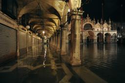
Venetians were placed on a 'yellow code' alert on Tuesday by officials concerned that an 'acqua alta' (high water) forecast of up to 110m above sea level will flood large areas of the lagoon city, including St Mark's Square.
The phenomenon is set to return with this evening's high tide and the water is expected to be about 105-110cm above normal by midnight, officials said.
Some 15,000 residents registered with the municipal alert system were informed via cell phone text message or on their telephone recording machines.
Officials warned that levels of 108cm normally swamp at least 10% of the city and floods St. Mark's square - the lowest area - with 30cm of water.
At the start of November, relentless winds helped push the sea level to 156cm above normal, the highest acqua alta since 158cm in 1986 and 166cm in December 1979.
The record acqua alta was in the great flood of 1966, at 194cm. Levels of 100-130 cm above sea level are fairly common in the lagoon city, which is well-equipped to cope with its rafts of pontoon walkways.
But anything much above 140cm risks swamping the city and washing the walkways away.
Scientists have conceived various ways of warding off the waters since the catastrophic 1966 flood, and a system of moveable flood barriers called MOSE is being installed after years of polemics.
Experts say there are three main reasons for high water in the city: the rising floor in the lagoon caused by incoming silt; the undermining of the islands by the extraction of methane gas in the sea off Venice; and the overall increase in sea levels caused by global warming.
